
Coadan:4735.1099 Menhire,bis zu 4 Meter hoch,von OstnachWest in 1167 Meter Langen Alignements(Granit-Steinreihen) in einem Halbkreis endend Le Ménec,Carnac ,Departement Morbihan,Bretagne Steffen Heilfort.JPG

Size of this preview: 800 × 600 pixels. Other resolutions: 320 × 240 pixels | 640 × 480 pixels | 1,024 × 768 pixels | 1,280 × 960 pixels | 2,560 × 1,920 pixels.
Jeeskeaylley ymlane (2,560 × 1,920 phixel, mooadys y choadan: 2.28 MB, sorçh MIME: image/jpeg)
_in_einem_Halbkreis_endend_Le_M%C3%A9nec,Carnac_,Departement_Morbihan,Bretagne_Steffen_Heilfort.JPG)
Giare-choontey
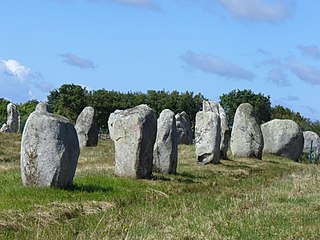
| Coontey | 1099 Menhire,bis zu 4 Meter hoch,von Ost nach West in 1167 Meter Langen Alignements(Steinreihen) in einem Halbkreis(Cromlechs) endend. (Jungsteinzeit, Neolithikum ,Neolithic ,Néolithique 4500-2300 v.Chr.) Megalithanlage von Le Ménec, Carnac ,Departement Morbihan ,Bretagne |
| Date | |
| Bun | Own work |
| Author | Steffen Heilfort |
| Object location | | View this and other nearby images on: OpenStreetMap |
|---|
_in_einem_Halbkreis_endend_Le_M%C3%A9nec,Carnac_,Departement_Morbihan,Bretagne_Steffen_Heilfort.JPG¶ms=047.592010_N_-003.085150_E_globe:Earth_class:object_region:FR_type:landmark_scale:1500_&language=gv)
|
This building is classé au titre des monuments historiques de la France. It is indexed in the base Mérimée, a database of architectural heritage maintained by the French Ministry of Culture, under the reference PA00091074
|
Kieddagh:

|
Permission is granted to copy, distribute and/or modify this document under the terms of the GNU Free Documentation License, Version 1.2 or any later version published by the Free Software Foundation; with no Invariant Sections, no Front-Cover Texts, and no Back-Cover Texts. A copy of the license is included in the section entitled GNU Free Documentation License. |
| This file is licensed under the Creative Commons Attribution-Share Alike 3.0 Unported license. | ||
| ||
| This licensing tag was added to this file as part of the GFDL licensing update. |
Shennaghys y choadan
Crig er daayt/am ennagh son fakin er y choadan myr v’eh ec y traa shen.
| Daayt/Am | Ingin-ordaag | Towshanyn | Ymmydeyr | Cohaggloo | |
|---|---|---|---|---|---|
| bio | 17:52, 30 Jerrey Fouyir 2007 | | 2,560 × 1,920 (2.28 MB) | Steffenheilfort | {{Information |Description=1099 Menhire,bis zu 4 Meter hoch,von Ost nach West in 1167 Meter Langen Alignements(Steinreihen) in einem Halbkreis(Cromlechs) endend. (Jungsteinzeit, Neolithikum ,Neolithic ,Néolithique 4500-2300 v.Chr.) Megalithanlage von Le |
Ymmyd y choadan
Ta ny 1 duillag eiyrtyssagh kianglt rish y choadan shoh:
Global file usage
The following other wikis use this file:
- Usage on ca.wikipedia.org
- Usage on en.wikipedia.org
- Usage on es.wikipedia.org
- Usage on fo.wikipedia.org
- Usage on fr.wikipedia.org
- Usage on fy.wikipedia.org
- Usage on it.wikipedia.org
- Usage on ja.wikipedia.org
- Usage on ko.wikipedia.org
- Usage on pl.wikipedia.org
- Usage on pt.wikipedia.org
_in_einem_Halbkreis_endend_Le_Ménec,Carnac_,Departement_Morbihan,Bretagne_Steffen_Heilfort.JPG)