
Coadan:Dactylorhiza baltica - Pakri.jpg

Size of this preview: 400 × 600 pixels. Other resolutions: 160 × 240 pixels | 320 × 480 pixels | 512 × 768 pixels | 682 × 1,024 pixels | 1,365 × 2,048 pixels | 4,000 × 6,000 pixels.
Jeeskeaylley ymlane (4,000 × 6,000 phixel, mooadys y choadan: 9.28 MB, sorçh MIME: image/jpeg)
Giare-choontey
| Coontey |
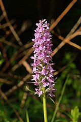
Eesti: Balti sõrmkäpp (Dactylorhiza baltica) Pakri poolsaarel. Kuulub looduskaitse all olevate liikide III kategooriasse. English: Dactylorhiza baltica on Pakri Peninsula, Northwestern Estonia. It belongs to the category III of protected species in the country. |
| Date | |
| Bun | Own work |
| Author | Ivar Leidus |
| Camera location | | View this and other nearby images on: OpenStreetMap |
|---|
Kieddagh:
I, the copyright holder of this work, hereby publish it under the following license:
This file is licensed under the Creative Commons Attribution-Share Alike 3.0 Unported license.
- You are free:
- to share – to copy, distribute and transmit the work
- to remix – to adapt the work
- Under the following conditions:
- attribution – You must give appropriate credit, provide a link to the license, and indicate if changes were made. You may do so in any reasonable manner, but not in any way that suggests the licensor endorses you or your use.
- share alike – If you remix, transform, or build upon the material, you must distribute your contributions under the same or compatible license as the original.
This image has been assessed using the Quality image guidelines and is considered a Quality image.
|
Shennaghys y choadan
Crig er daayt/am ennagh son fakin er y choadan myr v’eh ec y traa shen.
| Daayt/Am | Ingin-ordaag | Towshanyn | Ymmydeyr | Cohaggloo | |
|---|---|---|---|---|---|
| bio | 17:41, 24 Mean Souree 2013 | | 4,000 × 6,000 (9.28 MB) | Iifar | User created page with UploadWizard |
Ymmyd y choadan
Cha nel duillag erbee kianglt rish y choadan shoh.
Global file usage
The following other wikis use this file:
- Usage on da.wikipedia.org
- Usage on de.wikipedia.org
- Usage on es.wikipedia.org
- Usage on et.wikipedia.org
- Usage on fi.wikipedia.org
- Usage on lv.wikipedia.org
- Usage on pl.wikipedia.org
- Usage on pl.wikibooks.org
- Usage on ru.wikipedia.org
- Usage on uk.wikipedia.org
- Usage on vi.wikipedia.org