
Coadan:France 1939.png

Size of this preview: 800 × 351 pixels. Other resolutions: 320 × 140 pixels | 640 × 281 pixels | 1,425 × 625 pixels.
Jeeskeaylley ymlane (1,425 × 625 pixelyn, mooadys y choadan: 33 KB, sorçh MIME: image/png)
[This Map is badly colorized : Indochina (Annam, Tonkin, Cambodia, Laos), Pacific Islands, African countries, etc. are quite invisible.]

|
File:France 1939.svg is a vector version of this file. It should be used in place of this PNG file when not inferior.
File:France 1939.png → File:France 1939.svg
For more information, see Help:SVG. |
 |
Giare-choontey
| Coontey |
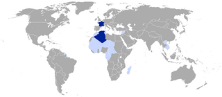
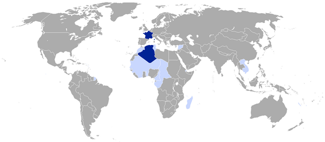
This map depicts the territorial situation of France subsequent to the 1939 en:Invasion of Poland.
|
||
| Date | |||
| Bun |
|
||
| Author | VoodooIsland | ||
| Permission (Reusing this file) |
|
Original upload log
The original description page was here. All following user names refer to en.wikipedia.
Upload date | User | Bytes | Dimensions | Comment
- 2011-09-09 00:38:29 | SpencerCS | 33545 | 1425×625 | Added French India
- 2010-04-29 10:55:54 | VoodooIsland | 58986 | 1425×625 | self-made
Shennaghys y choadan
Crig er daayt/am ennagh son fakin er y choadan myr v’eh ec y traa shen.
| Daayt/Am | Ingin-ordaag | Towshanyn | Ymmydeyr | Cohaggloo | |
|---|---|---|---|---|---|
| bio | 15:45, 4 Jerrey Souree 2023 | | 1,425 × 625 (33 KB) | Huic2856 | Revert; Algeria was made an integral part of Metropolitan France in 1848. |
| 12:56, 8 Boaldyn 2017 |  | 1,425 × 625 (33 KB) | Taketa | Reverted to version as of 06:03, 19 June 2016 (UTC) | |
| 12:52, 8 Boaldyn 2017 |  | 1,425 × 625 (33 KB) | Taketa | Revert, see talk page | |
| 06:03, 19 Mean Souree 2016 |  | 1,425 × 625 (33 KB) | Houmouvazine | Corrected Algeria to colonial departments status, per source | |
| 15:09, 30 Mee Houney 2011 |  | 1,425 × 625 (33 KB) | OwenBlacker | {{BotMoveToCommons|en.wikipedia|year={{subst:CURRENTYEAR}}|month={{subst:CURRENTMONTHNAME}}|day={{subst:CURRENTDAY}}}} The upload bot is User:CommonsHelper2 Bot which is called by [http://toolserver.org/~commonshelper2/index.php CommonsHelper2]. The t |
Ymmyd y choadan
Cha nel duillag erbee kianglt rish y choadan shoh.
Global file usage
The following other wikis use this file:
- Usage on en.wikipedia.org
- Usage on fr.wikipedia.org