
Coadan:Isle of Man A3 road (OpenStreetMap).png
Cha nel jeeskeaylley ny smoo ry-gheddyn.
Isle_of_Man_A3_road_(OpenStreetMap).png (436 × 491 pixel, mooadys y choadan: 72 KB, sorçh MIME: image/png)
.png)

|
This road map image could be re-created using vector graphics as an SVG file. This has several advantages; see Commons:Media for cleanup for more information. If an SVG form of this image is available, please upload it and afterwards replace this template with
{{vector version available|new image name}}.
It is recommended to name the SVG file “Isle of Man A3 road (OpenStreetMap).svg”—then the template Vector version available (or Vva) does not need the new image name parameter. |
| Description |
This map was created from OpenStreetMap project data, collected by the community. This map may be incomplete, and may contain errors. Don't rely solely on it for navigation. |
| Date | (see file history) |
| Bun | You may find a page on the OpenStreetMap wiki page for Isle of Man |
| Creator |
OpenStreetMap contributors |
| Permission (Reusing this file) |
OpenStreetMap data and maps are licensed under the Creative Commons Attribution-ShareAlike 2.0 license (CC-BY-SA 2.0). This file is licensed under the Creative Commons Attribution-Share Alike 2.0 Generic license.
|
| Georeferencing | If inappropriate please set warp_status = skip to hide. |
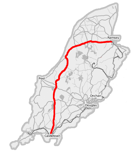
Overview map of the Isle of Man from OpenStreetMap project with the A3 Castletown to Ramsey road highlighted.
Source: Open Street Map of the Isle of Man
Shennaghys y choadan
Crig er daayt/am ennagh son fakin er y choadan myr v’eh ec y traa shen.
| Daayt/Am | Ingin-ordaag | Towshanyn | Ymmydeyr | Cohaggloo | |
|---|---|---|---|---|---|
| bio | 22:01, 9 Boaldyn 2007 | | 436 × 491 (72 KB) | Dankarran | {{openstreetmap|name=Isle of Man}} Overview map of the Isle of Man from OpenStreetMap project with the A3 Castletown to Ramsey road highlighted. {{CC-BY-SA 2.0}} Source: [http://www.openstreetmap.org/index.html?lat=54.22907&lon=-4.44500&zoom=10 Ope |
| 21:58, 9 Boaldyn 2007 |  | 436 × 491 (71 KB) | Dankarran | {{openstreetmap|name=Isle of Man}} Overview map of the Isle of Man from OpenStreetMap project with the A3 Castletown to Ramsey road highlighted. {{CC-BY-SA 2.0}} Source: [http://www.openstreetmap.org/index.html?lat=54.22907&lon=-4.44500&zoom=10 Ope |
Ymmyd y choadan
Ta ny 1 duillag eiyrtyssagh kianglt rish y choadan shoh:
Global file usage
The following other wikis use this file:
- Usage on en.wikipedia.org
- Usage on nl.wikipedia.org
- Usage on www.wikidata.org
.png)