
Coadan:Isle of Man map-en.svg

Size of this PNG preview of this SVG file: 654 × 600 pixels. Other resolutions: 262 × 240 pixels | 524 × 480 pixels | 838 × 768 pixels | 1,117 × 1,024 pixels | 2,234 × 2,048 pixels | 1,200 × 1,100 pixels.
Jeeskeaylley ymlane (coadan SVG, 1,200 × 1,100 phixel dy ennymagh, mooadys y choadan: 686 KB)

Giare-choontey
| Coontey |
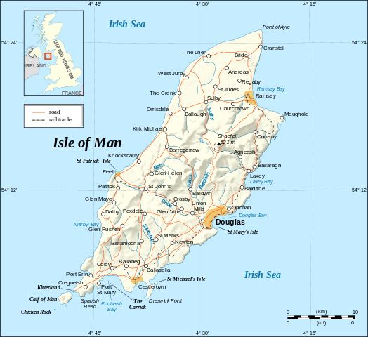
English: Map in English of the Isle of Man.
Note : The shaded relief is a raster image embedded in the SVG. Français : Carte en anglais de l'Île de Man. Note : Le relief ombré est une image bitmap incrustée dans le fichier SVG. UTM projection; WGS84 datum; shaded relief (composite image of N-W, W and N lightning positions); |
||
| Date | |||
| Bun |
Own work ;
|
||
| Author | Eric Gaba (Sting - fr:Sting) | ||
| Permission (Reusing this file) |
|
||
| Other versions |
[]
|


|
This SVG file contains embedded text that can be translated into your language, using any capable SVG editor, text editor or the SVG Translate tool. For more information see: About translating SVG files. |
Kieddagh:
I, the copyright holder of this work, hereby publish it under the following licenses:

|
Permission is granted to copy, distribute and/or modify this document under the terms of the GNU Free Documentation License, Version 1.2 or any later version published by the Free Software Foundation; with no Invariant Sections, no Front-Cover Texts, and no Back-Cover Texts. A copy of the license is included in the section entitled GNU Free Documentation License. |
| This file is licensed under the Creative Commons Attribution-Share Alike 3.0 Unported license. | ||
| ||
| This licensing tag was added to this file as part of the GFDL licensing update. |
This file is licensed under the Creative Commons Attribution-Share Alike 2.5 Generic, 2.0 Generic and 1.0 Generic license.
- You are free:
- to share – to copy, distribute and transmit the work
- to remix – to adapt the work
- Under the following conditions:
- attribution – You must give appropriate credit, provide a link to the license, and indicate if changes were made. You may do so in any reasonable manner, but not in any way that suggests the licensor endorses you or your use.
- share alike – If you remix, transform, or build upon the material, you must distribute your contributions under the same or compatible license as the original.
You may select the license of your choice.
Shennaghys y choadan
Crig er daayt/am ennagh son fakin er y choadan myr v’eh ec y traa shen.
| Daayt/Am | Ingin-ordaag | Towshanyn | Ymmydeyr | Cohaggloo | |
|---|---|---|---|---|---|
| bio | 14:38, 4 Mean Fouyir 2008 | | 1,200 × 1,100 (686 KB) | Sting | New standard colors |
| 23:03, 21 Boaldyn 2007 |  | 1,200 × 1,100 (786 KB) | Sting | {{Information |Description=Map in English of the Isle of Man |Source=Own work ;<br/>Background map and shaded relief : [http://www2.jpl.nasa.gov/srtm NASA Shuttle Radar Topography Mission] (SRTM3 v.2) (public domain) edited with [http: |
Ymmyd y choadan
Ta yn 2 duillag eiyrtyssagh kianglt rish y choadan shoh:
Global file usage
The following other wikis use this file:
- Usage on ca.wikipedia.org
- Usage on cv.wikipedia.org
- Usage on cy.wikipedia.org
- Usage on de.wikipedia.org
- Usage on en.wikipedia.org
- Usage on en.wikibooks.org
- Usage on en.wikisource.org
- Usage on eo.wikipedia.org
- Usage on es.wikipedia.org
- Usage on es.wiktionary.org
- Usage on fa.wikipedia.org
- Usage on frr.wikipedia.org
- Usage on gag.wikipedia.org
- Usage on ga.wikipedia.org
- Usage on ha.wikipedia.org
- Usage on hr.wikipedia.org
- Usage on ja.wikipedia.org
- Usage on kw.wikipedia.org
- Usage on lt.wikipedia.org
- Usage on mi.wikipedia.org
- Usage on mr.wikipedia.org
- Usage on nl.wikipedia.org
- Usage on sk.wikipedia.org
- Usage on sl.wikipedia.org
- Usage on stq.wikipedia.org
- Usage on tr.wikipedia.org
- Usage on tr.wiktionary.org
- Usage on vi.wikipedia.org
- Usage on vls.wikipedia.org
- Usage on zh.wikipedia.org