
Coadan:Kirk Braddan Old Church - geograph.org.uk - 24358.jpg
Cha nel jeeskeaylley ny smoo ry-gheddyn.
Kirk_Braddan_Old_Church_-_geograph.org.uk_-_24358.jpg (640 × 427 pixelyn, mooadys y choadan: 92 KB, sorçh MIME: image/jpeg)
Giare-choontey
| Coontey |
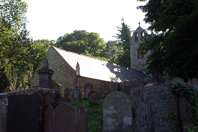
English: Kirk Braddan Old Church. The mother church of Douglas set in a beautiful wooded valley by the River Dhoo. The churchyard is full of Georgian head-stones and dominated by an obelisk designed by Steuart to Lord Henry Murray. Tower, 1773. Interior high pews, galleries, clear glass and monuments on walls.[JB]
Built 1773 following presentations that the roof and gable of the previous church were unsafe and also after complaints that the previous church was too small. The received wisdom is that the old church was demolished and the new built from the reclaimed rubble though with quoins of Foxdale granite. However recent surveys by Mr F. Cowin have convinced him that although the east end was demolished and rebuilt and the tower added, the remaining walls are mostly the original dating from the twelfth century. Following the precedent of St Marks (b 1772) the four corners were marked by pinnacles. Unlike many other island churches it was probably never whitewashed. |
| Date | |
| Bun | From geograph.org.uk |
| Author | Andy Stephenson |
| Attribution (required by the license) | Andy Stephenson / Kirk Braddan Old Church / |
| Object location | | View this and other nearby images on: OpenStreetMap |
|---|
_&language=gv)
Kieddagh:

|
This image was taken from the Geograph project collection. See this photograph's page on the Geograph website for the photographer's contact details. The copyright on this image is owned by Andy Stephenson and is licensed for reuse under the Creative Commons Attribution-ShareAlike 2.0 license.
|
This file is licensed under the Creative Commons Attribution-Share Alike 2.0 Generic license.
Attribution: Andy Stephenson
- You are free:
- to share – to copy, distribute and transmit the work
- to remix – to adapt the work
- Under the following conditions:
- attribution – You must give appropriate credit, provide a link to the license, and indicate if changes were made. You may do so in any reasonable manner, but not in any way that suggests the licensor endorses you or your use.
- share alike – If you remix, transform, or build upon the material, you must distribute your contributions under the same or compatible license as the original.
Shennaghys y choadan
Crig er daayt/am ennagh son fakin er y choadan myr v’eh ec y traa shen.
| Daayt/Am | Ingin-ordaag | Towshanyn | Ymmydeyr | Cohaggloo | |
|---|---|---|---|---|---|
| bio | 03:32, 30 Jerrey Geuree 2010 | | 640 × 427 (92 KB) | GeographBot | == {{int:filedesc}} == {{Information |description={{en|1=Kirk Braddan Old Church. The mother church of Douglas set in a beautiful wooded valley by the River Dhoo. The churchyard is full of Georgian head-stones and dominated by an obelisk designed by Steua |
Ymmyd y choadan
Ta ny 1 duillag eiyrtyssagh kianglt rish y choadan shoh:
Global file usage
The following other wikis use this file:
- Usage on arz.wikipedia.org
- Usage on de.wikipedia.org
- Usage on en.wikipedia.org
- Usage on fr.wikipedia.org
- Usage on nl.wikipedia.org
- Usage on ru.wikipedia.org
- Usage on sk.wikipedia.org
- Usage on www.wikidata.org