
Coadan:Scottish infobox template map.png

Size of this preview: 451 × 600 pixels. Other resolutions: 180 × 240 pixels | 361 × 480 pixels | 577 × 768 pixels | 1,154 × 1,535 pixels.
Jeeskeaylley ymlane (1,154 × 1,535 pixelyn, mooadys y choadan: 661 KB, sorçh MIME: image/png)
Giare-choontey
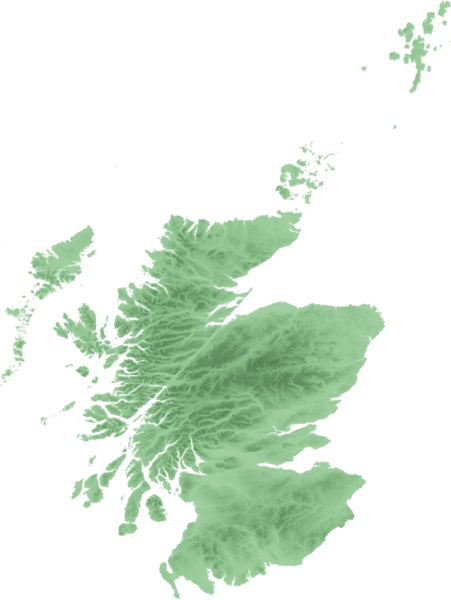
| Coontey | Topo map of Scotland for use in Scottish infoboxes - equidistant cylindrical projection as naturaly outputted from SRTM data, stretched 150% vertically as deduced by w:User:Anameofmyveryown for easier viewing. |
| Date | |
| Bun | SRTM data from NASA, PD |
| Author | SFC9394 |
Kieddagh:

|
Permission is granted to copy, distribute and/or modify this document under the terms of the GNU Free Documentation License, Version 1.2 or any later version published by the Free Software Foundation; with no Invariant Sections, no Front-Cover Texts, and no Back-Cover Texts. A copy of the license is included in the section entitled GNU Free Documentation License. |
| This file is licensed under the Creative Commons Attribution-Share Alike 3.0 Unported license. | ||
| ||
| This licensing tag was added to this file as part of the GFDL licensing update. |
Shennaghys y choadan
Crig er daayt/am ennagh son fakin er y choadan myr v’eh ec y traa shen.
| Daayt/Am | Ingin-ordaag | Towshanyn | Ymmydeyr | Cohaggloo | |
|---|---|---|---|---|---|
| bio | 22:48, 21 Mean Fouyir 2007 | | 1,154 × 1,535 (661 KB) | SFC9394 | {{Information |Description=Topo map of Scotland for use in Scottish infoboxes - equidistant cylindrical projection as naturaly outputted from SRTM data, stretched 150% vertically as deduced by w:User:Anameofmyveryown for easier viewing. |Source=SRTM d |
Ymmyd y choadan
Ta ny 5 duillagyn eiyrtyssagh kianglt rish y choadan shoh:
Global file usage
The following other wikis use this file:
- Usage on am.wikipedia.org
- Usage on as.wikipedia.org
- Usage on awa.wikipedia.org
- Usage on azb.wikipedia.org
- Usage on bn.wikipedia.org
- Usage on da.wikipedia.org
- Usage on diq.wikipedia.org
- Usage on en.wikipedia.org
- User talk:SFC9394
- Wikipedia talk:WikiProject Scotland/Archive 6
- Template:Location mark+
- Template:Location mark+/doc
- Template:Location mark+/testcases
- Template:Location mark
- Template:Location mark/doc
- Template:Location mark~/testcases
- Template:Location mark+/sandbox
- Template:Location mark/sandbox
- Template:Location mark label
- Usage on en.wikiversity.org
- Usage on fa.wikipedia.org
- Usage on fo.wikipedia.org
- Usage on fr.wikipedia.org
- Usage on hi.wikipedia.org
- Usage on hy.wikipedia.org
View more global usage of this file.