
Coadan:WalesGwynedd.png
Cha nel jeeskeaylley ny smoo ry-gheddyn.
WalesGwynedd.png (200 × 225 pixelyn, mooadys y choadan: 22 KB, sorçh MIME: image/png)
Giare-choontey
Map of Gwynedd —Walden69 12:16, 11 April 2006 (UTC)
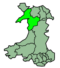
| Coontey | English map of Gwynedd (one of the subdivisions of Wales) |
| Date | of this version : 21 January 2004 |
| Bun | Morwen |
| Author | Morwen |
| Permission (Reusing this file) |
GFDL |
| Other versions | en:Image:WalesGwynedd.png |
Image history on en:
| Date | Author | Edit summary |
| 23:36, 21 January 2004 | en:Morwen (Talk) | 200x225 (22,409 bytes) (one of the en:subdivisions of Wales) |
Kieddagh:
| This file is licensed under the Creative Commons Attribution-Share Alike 3.0 Unported license. Subject to disclaimers. | ||
| ||
| This licensing tag was added to this file as part of the GFDL licensing update. |

|
Permission is granted to copy, distribute and/or modify this document under the terms of the GNU Free Documentation License, Version 1.2 or any later version published by the Free Software Foundation; with no Invariant Sections, no Front-Cover Texts, and no Back-Cover Texts. A copy of the license is included in the section entitled GNU Free Documentation License. Subject to disclaimers. |
Shennaghys y choadan
Crig er daayt/am ennagh son fakin er y choadan myr v’eh ec y traa shen.
| Daayt/Am | Ingin-ordaag | Towshanyn | Ymmydeyr | Cohaggloo | |
|---|---|---|---|---|---|
| bio | 12:16, 11 Averil 2006 | | 200 × 225 (22 KB) | Walden69 | Mapa de Gwynedd {{PD-user|Morwen}}—~~~~Category:Maps of Wales |
Ymmyd y choadan
Ta ny 1 duillag eiyrtyssagh kianglt rish y choadan shoh:
Global file usage
The following other wikis use this file:
- Usage on be.wikipedia.org
- Usage on bg.wikipedia.org
- Usage on br.wikipedia.org
- Usage on ca.wikipedia.org
- Usage on cs.wikipedia.org
- Usage on cy.wikipedia.org
- Gwynedd
- Blaenau Ffestiniog
- Bae Tremadog
- Llanberis
- Afon Dyfi
- Prifysgol Bangor
- Y Faenol
- Rheilffordd yr Wyddfa
- Rachub
- Afon Dwyfor
- Afon Dysynni
- Afon Dwyryd
- Tremadog
- Glyderau
- Y Moelwynion
- Afon Adda
- Llanfachreth, Gwynedd
- Rhostryfan
- Chwilog
- Chwarel Vivian
- Peniarth
- Llanddeiniolen
- Bwlch y Groes
- Abergynolwyn
- Hendregadredd
- Moelwyn Bach
- Rheilffordd Corris
- Moel Tryfan
- Afon Erch
- Llanfihangel-y-Pennant (Cwm Pennant)
- Bontnewydd, Meirionnydd
- Afon Wnion
- Bryncroes
- Mynytho
- Tŷ Newydd (Canolfan)
- Talsarnau
- Llyn Padarn
- Llyn Arenig Fawr
View more global usage of this file.