
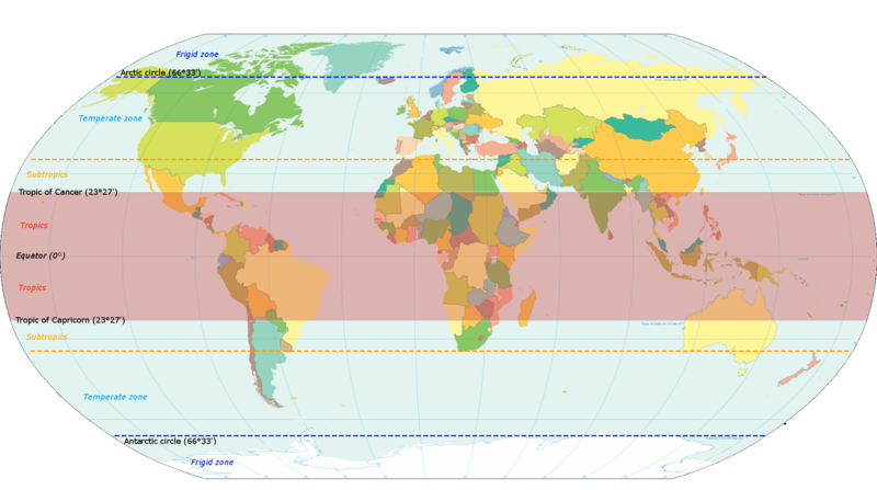
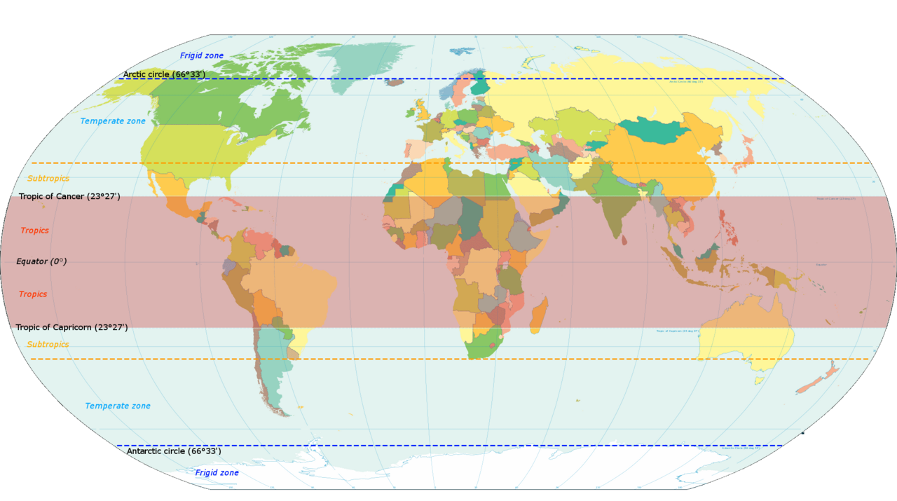
Coadan:World map indicating tropics and subtropics.png
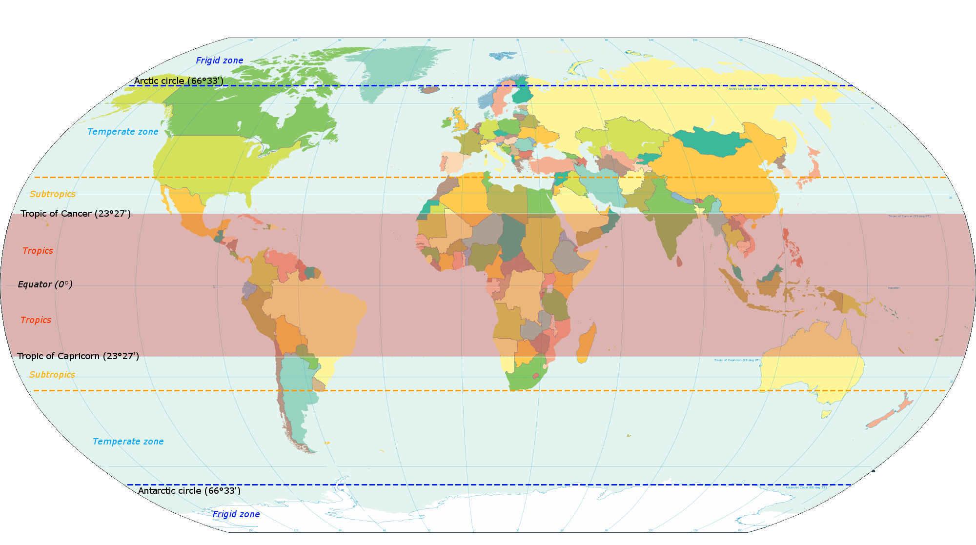
Size of this preview: 800 × 447 pixels. Other resolutions: 320 × 179 pixels | 640 × 357 pixels | 1,024 × 572 pixels | 1,280 × 715 pixels | 2,000 × 1,117 pixels.
Jeeskeaylley ymlane (2,000 × 1,117 pixelyn, mooadys y choadan: 131 KB, sorçh MIME: image/png)
Giare-choontey
| Coontey |
English: Map based on File:World map torrid.svg, now indicating subtropics. Map was made by closely examining this map to get latitude accurately correct. |
| Date | |
| Bun | Own work |
| Author | KVDP |
Kieddagh:
I, the copyright holder of this work, hereby publish it under the following license:
This file is licensed under the Creative Commons Attribution-Share Alike 3.0 Unported license.
- You are free:
- to share – to copy, distribute and transmit the work
- to remix – to adapt the work
- Under the following conditions:
- attribution – You must give appropriate credit, provide a link to the license, and indicate if changes were made. You may do so in any reasonable manner, but not in any way that suggests the licensor endorses you or your use.
- share alike – If you remix, transform, or build upon the material, you must distribute your contributions under the same or compatible license as the original.
Shennaghys y choadan
Crig er daayt/am ennagh son fakin er y choadan myr v’eh ec y traa shen.
| Daayt/Am | Ingin-ordaag | Towshanyn | Ymmydeyr | Cohaggloo | |
|---|---|---|---|---|---|
| bio | 18:13, 13 Mayrnt 2014 | | 2,000 × 1,117 (131 KB) | Genetics4good | Reverted to version as of 10:31, 20 November 2013 |
| 18:09, 13 Mayrnt 2014 |  | 2,000 × 1,117 (465 KB) | Genetics4good | Reverted to version as of 06:44, 23 July 2013 | |
| 10:31, 20 Mee Houney 2013 |  | 2,000 × 1,117 (131 KB) | Maproom | My fourth attempt. I am making a real mess of this. | |
| 18:46, 19 Mee Houney 2013 |  | 2,000 × 1,117 (131 KB) | Maproom | A third attempt, with the corrections AND the transparency this time, I hope. | |
| 10:28, 13 Mee Houney 2013 |  | 2,000 × 1,117 (131 KB) | Maproom | Restored background transparency, which I had accidentally removed | |
| 10:23, 13 Mee Houney 2013 |  | 2,000 × 1,117 (422 KB) | Maproom | Removed labels "68" on two lines of latitude - the lines are in the right position (as limits of subtropical zone), but are not at 68 north and south. Added a "c" to "Antarctic". | |
| 06:44, 23 Jerrey Souree 2013 |  | 2,000 × 1,117 (465 KB) | Genetics4good | Added temperate and frigid zone | |
| 15:53, 22 Jerrey Souree 2013 |  | 2,000 × 1,117 (452 KB) | Genetics4good | User created page with UploadWizard |
Ymmyd y choadan
Ta ny 1 duillag eiyrtyssagh kianglt rish y choadan shoh:
Global file usage
The following other wikis use this file:
- Usage on ar.wikipedia.org
- Usage on arz.wikipedia.org
- Usage on bg.wikipedia.org
- Usage on bh.wikipedia.org
- Usage on bn.wikipedia.org
- Usage on ca.wikipedia.org
- Usage on en.wikipedia.org
- Usage on en.wikiversity.org
- Usage on en.wikivoyage.org
- Usage on en.wiktionary.org
- Usage on fi.wikipedia.org
- Usage on fi.wiktionary.org
- Usage on ga.wikipedia.org
- Usage on ha.wikipedia.org
- Usage on he.wikivoyage.org
- Usage on id.wikipedia.org
- Usage on ilo.wikipedia.org
- Usage on ms.wikipedia.org
- Usage on my.wikipedia.org
- Usage on ro.wikipedia.org
- Usage on sco.wikipedia.org
- Usage on sd.wikipedia.org
- Usage on sr.wikipedia.org
- Usage on su.wikipedia.org
- Usage on th.wikipedia.org
- Usage on tr.wikipedia.org
- Usage on ur.wikipedia.org
- Usage on war.wikipedia.org
- Usage on www.wikidata.org
- Usage on zh-yue.wikipedia.org
- Usage on zh.wikipedia.org