
Coadan:Edinburgh Scottish Parliament01 2006-04-29.jpg
Jeeskeaylley ymlane (2,610 × 1,932 phixel, mooadys y choadan: 1.42 MB, sorçh MIME: image/jpeg)
Giare-choontey
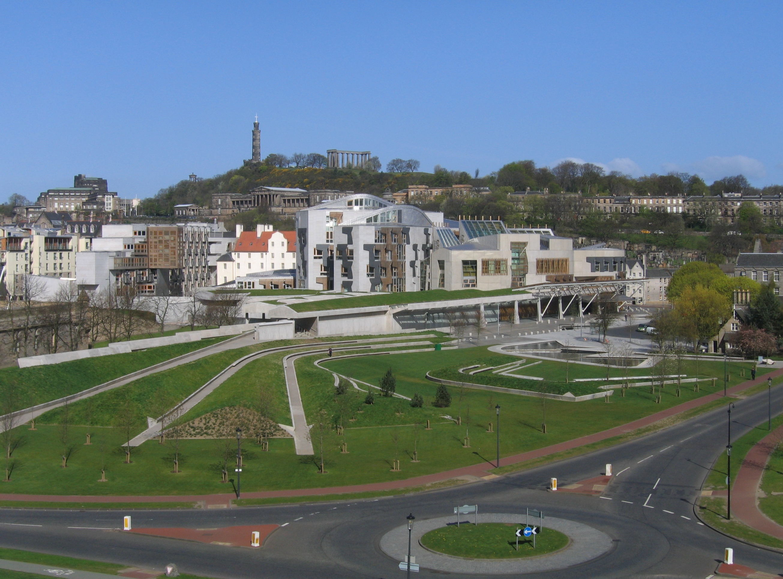
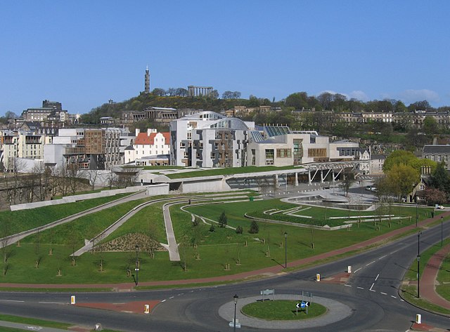
The Scottish Parliament in Edinburgh seen from halfway up Salisbury Crags, just below the Radical Road. On the left is the wing with the thinking pods. Queensberry House (white with a red roof), a historic building, was incorporated into the parliament site. Just above Queensberry House, on the slope of Calton Hill, is the Royal High School, a prior candidate for housing the parliament. On top of Calton Hill one can see the tower of the Nelson Monument and to its right the National Monument.
Based on own photo, taken 29 April 2006 (see filename of course).
Vertical object features vertically aligned with hugin, small missing parts at the edges (caused by the remapping) filled in with enblend using a wid(er) angle shot from the same camera position.
| Camera location | | View this and other nearby images on: OpenStreetMap |
|---|
Kieddagh:

|
Permission is granted to copy, distribute and/or modify this document under the terms of the GNU Free Documentation License, Version 1.2 or any later version published by the Free Software Foundation; with no Invariant Sections, no Front-Cover Texts, and no Back-Cover Texts. A copy of the license is included in the section entitled GNU Free Documentation License. |
| This file is licensed under the Creative Commons Attribution-Share Alike 3.0 Unported license. | ||
| ||
| This licensing tag was added to this file as part of the GFDL licensing update. |
- You are free:
- to share – to copy, distribute and transmit the work
- to remix – to adapt the work
- Under the following conditions:
- attribution – You must give appropriate credit, provide a link to the license, and indicate if changes were made. You may do so in any reasonable manner, but not in any way that suggests the licensor endorses you or your use.
- share alike – If you remix, transform, or build upon the material, you must distribute your contributions under the same or compatible license as the original.
Shennaghys y choadan
Crig er daayt/am ennagh son fakin er y choadan myr v’eh ec y traa shen.
| Daayt/Am | Ingin-ordaag | Towshanyn | Ymmydeyr | Cohaggloo | |
|---|---|---|---|---|---|
| bio | 08:39, 8 Mean Souree 2007 | | 2,610 × 1,932 (1.42 MB) | Klaus with K | |
| 14:41, 29 Averil 2006 |  | 2,592 × 1,944 (1.17 MB) | Klaus with K | own photo, from halfway up Salisbury Craigs |
Ymmyd y choadan
Ta ny 1 duillag eiyrtyssagh kianglt rish y choadan shoh:
Global file usage
The following other wikis use this file:
- Usage on arz.wikipedia.org
- Usage on ast.wikipedia.org
- Usage on bg.wikipedia.org
- Usage on br.wikipedia.org
- Usage on bs.wikipedia.org
- Usage on ca.wikipedia.org
- Usage on cs.wikipedia.org
- Usage on cy.wikipedia.org
- Usage on da.wikipedia.org
- Usage on de.wikipedia.org
- Usage on el.wikipedia.org
- Usage on en.wikipedia.org
- Politics of the United Kingdom
- Stirling Prize
- Enric Miralles
- Talk:Scottish Parliament Building
- Category:Politics of Scotland
- Portal:Architecture/Selected article archive
- Wikipedia:Today's featured article/May 2007
- Wikipedia:Today's featured article/May 2, 2007
- Portal:United Kingdom/Featured article
- Portal:United Kingdom/Featured article/17
- Portal:Scotland/Selected article/2007
- Portal:Scotland/Selected article/Week 24, 2007
- Outline of the United Kingdom
- Portal:Scotland/Selected picture/2009
- Portal:Scotland/Selected picture/June, 2009
- Talk:United Kingdom/Archive 18
- Architecture of Scotland
- User:Saalstin/Governance of the United Kingdom
- Scots law
- Talk:Scottish Parliament/Archive 1
- Usage on eo.wikipedia.org
- Usage on es.wikipedia.org
- Usage on eu.wikipedia.org
- Usage on fa.wikipedia.org
- Usage on fi.wikipedia.org
- Usage on fr.wikipedia.org
- Usage on gu.wikipedia.org
- Usage on he.wikipedia.org
- Usage on hi.wikipedia.org
View more global usage of this file.