
Coadan:EnglandIsleWight.svg

Size of this PNG preview of this SVG file: 200 × 247 pixels. Other resolutions: 194 × 240 pixels | 389 × 480 pixels | 622 × 768 pixels | 829 × 1,024 pixels | 1,658 × 2,048 pixels.
Jeeskeaylley ymlane (coadan SVG, 200 × 247 pixelyn dy ennymagh, mooadys y choadan: 232 KB)
Giare-choontey
| Coontey |
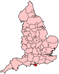
English: Map of the Isle of Wight within England. |
| Bun | Own work |
| Author | Wereon |
Kieddagh:
| I, the copyright holder of this work, release this work into the public domain. This applies worldwide. In some countries this may not be legally possible; if so: I grant anyone the right to use this work for any purpose, without any conditions, unless such conditions are required by law. |
Shennaghys y choadan
Crig er daayt/am ennagh son fakin er y choadan myr v’eh ec y traa shen.
| Daayt/Am | Ingin-ordaag | Towshanyn | Ymmydeyr | Cohaggloo | |
|---|---|---|---|---|---|
| bio | 23:48, 26 Averil 2007 | | 200 × 247 (232 KB) | Wereon | Map of the Isle of Wight within England. Category:Maps of counties of England |
Ymmyd y choadan
Ta ny 1 duillag eiyrtyssagh kianglt rish y choadan shoh:
Global file usage
The following other wikis use this file:
- Usage on cy.wikipedia.org
- Usage on en.wikipedia.org
- Usage on fr.wikipedia.org
- Usage on it.wikipedia.org
- Usage on ko.wikipedia.org
- Usage on pl.wikipedia.org
- Usage on pt.wikipedia.org
- Usage on simple.wikipedia.org
- Usage on zh.wikipedia.org