
Coadan:Merseyside UK location map.svg

Size of this PNG preview of this SVG file: 565 × 599 pixels. Other resolutions: 226 × 240 pixels | 453 × 480 pixels | 724 × 768 pixels | 966 × 1,024 pixels | 1,932 × 2,048 pixels | 1,231 × 1,305 pixels.
Jeeskeaylley ymlane (coadan SVG, 1,231 × 1,305 pixelyn dy ennymagh, mooadys y choadan: 1.3 MB)
| Coontey |
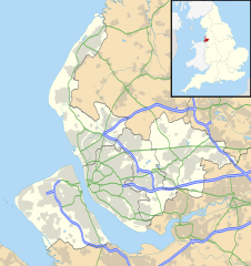
Map of Merseyside, UK with the following information shown:
Equirectangular map projection on WGS 84 datum, with N/S stretched 165% Geographic limits:
|
| Date | |
| Bun |
|
| Author | Nilfanion, created using Ordnance Survey data |
| Permission (Reusing this file) |
This file is licensed under the Creative Commons Attribution-Share Alike 3.0 Unported license. Attribution: Contains Ordnance Survey data © Crown copyright and database right
|
| Other versions | File:Bedfordshire UK district map (blank).svg - Blank map |
.svg)
Shennaghys y choadan
Crig er daayt/am ennagh son fakin er y choadan myr v’eh ec y traa shen.
| Daayt/Am | Ingin-ordaag | Towshanyn | Ymmydeyr | Cohaggloo | |
|---|---|---|---|---|---|
| bio | 19:01, 26 Mean Fouyir 2010 | | 1,231 × 1,305 (1.3 MB) | Nilfanion | {{Information |Description=Map of Merseyside, UK with the following information shown: *Administrative borders *Coastline, lakes and rivers *Roads and railways *Urban areas Equirectangular map projection on WGS 84 datum, with N/S stretche |
Ymmyd y choadan
Ta yn 2 duillag eiyrtyssagh kianglt rish y choadan shoh:
Global file usage
The following other wikis use this file:
- Usage on ar.wikipedia.org
- Usage on ast.wikipedia.org
- Usage on bg.wikipedia.org
- Usage on br.wikipedia.org
- Usage on ceb.wikipedia.org
- Usage on en.wikipedia.org
- Liverpool John Lennon Airport
- Leasowe
- Birkenhead
- Prescot
- Kirkby
- Halewood
- Huyton
- Southport
- Rainhill
- Earlestown
- Bootle
- Great Crosby
- Newton-le-Willows
- Edge Hill, Liverpool
- Litherland
- Formby
- Maghull
- Aigburth
- Allerton, Liverpool
- St Michael's Hamlet
- Crosby, Merseyside
- Little Crosby
- Waterloo, Merseyside
- RAF Woodvale
- Liverpool Castle
- Bebington
- Toxteth
- Birkdale
- Hoylake
- West Derby
- Norris Green
- Everton, Liverpool
- Croxteth
- Anfield (suburb)
- Aintree
- Port Sunlight
- Dingle, Liverpool
- Lydiate
- Switch Island
- Melling, Merseyside
- Sefton, Merseyside
- Rainford
- Speke
- Childwall
View more global usage of this file.