
Coadan:Pat map.PNG
Size of this preview: 440 × 599 pixels. Other resolutions: 176 × 240 pixels | 519 × 707 pixels.
Jeeskeaylley ymlane (519 × 707 pixelyn, mooadys y choadan: 23 KB, sorçh MIME: image/png)
Giare-choontey
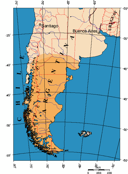
Map indicating Patagonia area in Southern South America. Modification of a GMT map.
Kieddagh:

|
Permission is granted to copy, distribute and/or modify this document under the terms of the GNU Free Documentation License, Version 1.2 or any later version published by the Free Software Foundation; with no Invariant Sections, no Front-Cover Texts, and no Back-Cover Texts. A copy of the license is included in the section entitled GNU Free Documentation License. |
| This file is licensed under the Creative Commons Attribution-Share Alike 3.0 Unported license. | ||
| ||
| This licensing tag was added to this file as part of the GFDL licensing update. |
Shennaghys y choadan
Crig er daayt/am ennagh son fakin er y choadan myr v’eh ec y traa shen.
| Daayt/Am | Ingin-ordaag | Towshanyn | Ymmydeyr | Cohaggloo | |
|---|---|---|---|---|---|
| bio | 22:18, 15 Luanistyn 2023 | | 519 × 707 (23 KB) | Janitoalevic | Reverted to version as of 18:27, 6 November 2022 (UTC) |
| 03:02, 30 Mee ny Nollick 2022 |  | 519 × 707 (26 KB) | Wikiedro | Reverted to version as of 15:14, 12 December 2018 (UTC) | |
| 18:27, 6 Mee Houney 2022 |  | 519 × 707 (23 KB) | Nihil scimus | Shaded according to the majority of maps. Chiloe does not belong to Patagonia | |
| 15:14, 12 Mee ny Nollick 2018 |  | 519 × 707 (26 KB) | Janitoalevic | Huincul Fault as northern border | |
| 00:58, 1 Luanistyn 2018 |  | 519 × 707 (27 KB) | Janitoalevic | Reverted to version as of 21:14, 15 August 2017 (UTC) | |
| 23:12, 20 Luanistyn 2017 |  | 519 × 707 (27 KB) | Janitoalevic | Reverted to version as of 19:06, 16 July 2016 (UTC) | |
| 21:14, 15 Luanistyn 2017 |  | 519 × 707 (27 KB) | Janitoalevic | Added new chilean region | |
| 19:06, 16 Jerrey Souree 2016 |  | 519 × 707 (27 KB) | Janitoalevic | fixed the uncolored pixel in the border. | |
| 23:47, 15 Jerrey Souree 2016 |  | 519 × 707 (27 KB) | Janitoalevic | Added Los Ríos Region border | |
| 01:09, 2 Boaldyn 2006 |  | 519 × 707 (35 KB) | Gi | Map indicating Patagonia area in Southern South America. Modification of an GMT map. |
Ymmyd y choadan
Ta ny 1 duillag eiyrtyssagh kianglt rish y choadan shoh:
Global file usage
The following other wikis use this file:
- Usage on af.wikipedia.org
- Usage on ar.wikipedia.org
- Usage on ast.wikipedia.org
- Usage on az.wikipedia.org
- Usage on be-tarask.wikipedia.org
- Usage on be.wikipedia.org
- Usage on bg.wikipedia.org
- Usage on bn.wikipedia.org
- Usage on br.wikipedia.org
- Usage on bs.wikipedia.org
- Usage on ca.wikipedia.org
- Usage on cs.wikipedia.org
- Usage on cy.wikipedia.org
- Usage on da.wikipedia.org
- Usage on de.wikipedia.org
- Usage on el.wikipedia.org
- Usage on en.wikipedia.org
- Usage on eo.wikipedia.org
- Usage on es.wikipedia.org
- Usage on es.wikisource.org
- Usage on et.wikipedia.org
- Usage on eu.wikipedia.org
- Usage on fa.wikipedia.org
- Usage on fi.wikipedia.org
- Usage on fo.wikipedia.org
- Usage on frp.wikipedia.org
- Usage on fr.wikipedia.org
- Usage on fy.wikipedia.org
- Usage on ga.wikipedia.org
- Usage on gl.wikipedia.org
- Usage on gn.wikipedia.org
- Usage on he.wikipedia.org
- Usage on hr.wikipedia.org
- Usage on hu.wikipedia.org
- Usage on hy.wikipedia.org
- Usage on id.wikipedia.org
- Usage on is.wikipedia.org
- Usage on it.wikipedia.org
- Usage on ja.wikipedia.org
- Usage on ka.wikipedia.org
- Usage on kbd.wikipedia.org
View more global usage of this file.