
Coadan:Topography of Ireland.jpg

Size of this preview: 474 × 600 pixels. Other resolutions: 190 × 240 pixels | 379 × 480 pixels | 607 × 768 pixels | 809 × 1,024 pixels | 1,618 × 2,048 pixels | 3,293 × 4,168 pixels.
Jeeskeaylley ymlane (3,293 × 4,168 pixelyn, mooadys y choadan: 3.86 MB, sorçh MIME: image/jpeg)
Giare-choontey
| Coontey |
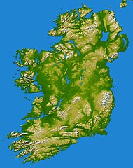
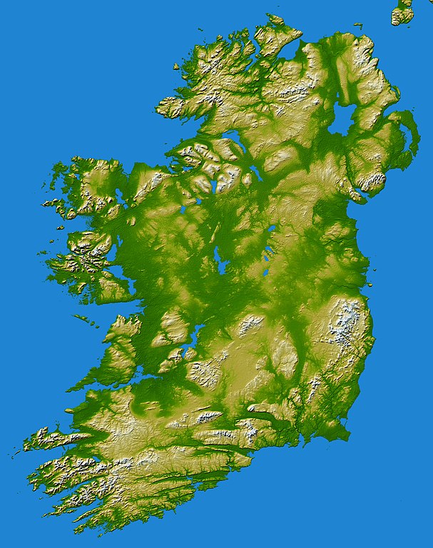
earthobservatory.nasa.gov/IOTD/view.php?id=5343 Elevation data used in this image were acquired by the Shuttle Radar Topography Mission aboard the Space Shuttle Endeavour, launched on Feb. 11, 2000. SRTM used the same radar instrument that comprised the Spaceborne Imaging Radar-C/X-Band Synthetic Aperture Radar (SIR-C/X-SAR) that flew twice on the Space Shuttle Endeavour in 1994. SRTM was designed to collect 3-D measurements of the Earth's surface. To collect the 3-D data, engineers added a 60-meter (approximately 200-foot) mast, installed additional C-band and X-band antennas, and improved tracking and navigation devices. The mission is a cooperative project between NASA, the National Geospatial-Intelligence Agency (NGA) of the U.S. Department of Defense and the German and Italian space agencies. It is managed by NASA's Jet Propulsion Laboratory, Pasadena, Calif., for NASA's Earth Science Enterprise, Washington, D.C.Topography of Ireland - Feb 2000 |
| Date | |
| Bun | Flickr |
| Author | Danny McL from Whitechapel, London, UK |
| Reviewer | File Upload Bot (Magnus Manske) |
Kieddagh:
This file is licensed under the Creative Commons Attribution-Share Alike 2.0 Generic license.
- You are free:
- to share – to copy, distribute and transmit the work
- to remix – to adapt the work
- Under the following conditions:
- attribution – You must give appropriate credit, provide a link to the license, and indicate if changes were made. You may do so in any reasonable manner, but not in any way that suggests the licensor endorses you or your use.
- share alike – If you remix, transform, or build upon the material, you must distribute your contributions under the same or compatible license as the original.
| This image, originally posted to Flickr, was reviewed on May 31, 2010 by the administrator or reviewer File Upload Bot (Magnus Manske), who confirmed that it was available on Flickr under the stated license on that date. |
Shennaghys y choadan
Crig er daayt/am ennagh son fakin er y choadan myr v’eh ec y traa shen.
| Daayt/Am | Ingin-ordaag | Towshanyn | Ymmydeyr | Cohaggloo | |
|---|---|---|---|---|---|
| bio | 07:27, 31 Boaldyn 2010 | | 3,293 × 4,168 (3.86 MB) | File Upload Bot (Magnus Manske) | {{Information |Description=[http://earthobservatory.nasa.gov/IOTD/view.php?id=5343 earthobservatory.nasa.gov/IOTD/view.php?id=5343] Elevation data used in this image were acquired by the Shuttle Radar Topography Mission aboard the Space Shuttle Endeavour |
Ymmyd y choadan
Ta ny 4 duillagyn eiyrtyssagh kianglt rish y choadan shoh:
Global file usage
The following other wikis use this file:
- Usage on an.wikipedia.org
- Usage on de.wikibooks.org
- Usage on hu.wikipedia.org
- Usage on kab.wikipedia.org