
Coadan:Udmurt03.png
Size of this preview: 433 × 599 pixels. Other resolutions: 173 × 240 pixels | 549 × 760 pixels.
Jeeskeaylley ymlane (549 × 760 phixel, mooadys y choadan: 33 KB, sorçh MIME: image/png)
Giare-choontey
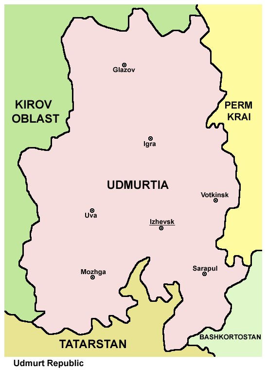
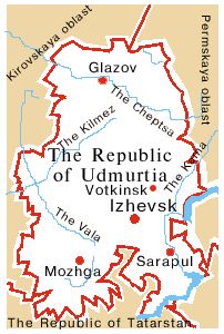
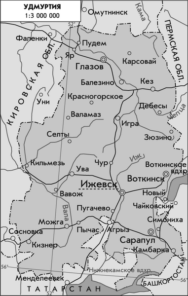
- Map of Udmurtia.
Source and license

|
This map has been uploaded by Electionworld from en.wikipedia.org to enable the |
Map made by PANONIAN
| This work has been released into the public domain by its author, PANONIAN. This applies worldwide. In some countries this may not be legally possible; if so: |
References
Maps from external links:
- http://www.fennougria.ee/public/udmurdi_kaart.jpg
- http://www.rdaward.org/map/4w.jpg
- http://www.museum.com.ua/project/club/otkritki/russia/map/udmurtia.jpg
- https://www.usrbc.org/pics/Image/Russian%20Regions/Udmurtia/map_udmurtia.jpg
- http://1.bp.blogspot.com/_i_q3O2fWjm4/TOh-Me3FEtI/AAAAAAAAAHs/ihLMS3uaBVE/s1600/udmurtia.jpg
- http://map.rin.ru/maps_e/Udmurty.gif
- http://www.udm.ru/icons/udm/parade/0042.gif
- http://2.bp.blogspot.com/_i_q3O2fWjm4/TOZo9D-1rfI/AAAAAAAAAHU/EBg9pTFI2t0/s1600/middlevolga19001500.jpg
- http://www.izhevskmaps.ru/images/stories/images5/udmurtia12.jpg
- http://www.izhevskmaps.ru/images/stories/images5/udmurtia22.gif
- http://www.izhevskmaps.ru/images/stories/images5/udmurtia24.jpg
- http://www.izhevskmaps.ru/images/stories/images5/udmurtia20.gif
- http://izhevsk.skyportal.ru/pic_izhevsk/udmurtia.jpg
- http://russia.at.ua/Atlas-of-Russia/Republic-of-Udmurtia.jpg
- http://dm-iz.com/UDM/map-udmurtia.jpg
- http://www.regions.newsall.ru/udmurtia/udmurtia.htm.gif
- http://www.izhevskmaps.ru/images/stories/images5/udmurtia31.jpg
- http://www.izhevskmaps.ru/images/stories/images5/udmurtia29.gif
- http://dic.academic.ru/pictures/enc_geo/Udmurtia.jpg
Largest cities and towns of Udmurtia:
Shennaghys y choadan
Crig er daayt/am ennagh son fakin er y choadan myr v’eh ec y traa shen.
| Daayt/Am | Ingin-ordaag | Towshanyn | Ymmydeyr | Cohaggloo | |
|---|---|---|---|---|---|
| bio | 16:18, 7 Jerrey Souree 2012 | | 549 × 760 (33 KB) | PANONIAN | improved version |
| 16:07, 29 Mee ny Nollick 2006 |  | 420 × 600 (18 KB) | Electionworld | {{ew|en|PANONIAN}} Map made by PANONIAN {{PD-user|PANONIAN}} Category:Maps of the Russian republics |
Ymmyd y choadan
Ta ny 1 duillag eiyrtyssagh kianglt rish y choadan shoh:
Global file usage
The following other wikis use this file:
- Usage on ace.wikipedia.org
- Usage on am.wikipedia.org
- Usage on ast.wikipedia.org
- Usage on ba.wikipedia.org
- Usage on be-tarask.wikipedia.org
- Usage on be.wikipedia.org
- Usage on bs.wikipedia.org
- Usage on ca.wikipedia.org
- Usage on csb.wikipedia.org
- Usage on cs.wikipedia.org
- Usage on cv.wikipedia.org
- Usage on da.wikipedia.org
- Usage on de.wikipedia.org
- Usage on en.wikipedia.org
- Usage on eo.wikipedia.org
- Usage on es.wikipedia.org
- Usage on fa.wikipedia.org
- Usage on fr.wikipedia.org
- Usage on ga.wikipedia.org
- Usage on hi.wikipedia.org
- Usage on hr.wikipedia.org
- Usage on id.wikipedia.org
- Usage on is.wikipedia.org
- Usage on ja.wikipedia.org
- Usage on ka.wikipedia.org
- Usage on koi.wikipedia.org
- Usage on ko.wikipedia.org
- Usage on lad.wikipedia.org
- Usage on la.wikipedia.org
- Usage on lt.wikipedia.org
- Usage on mhr.wikipedia.org
- Usage on mk.wikipedia.org
- Usage on mn.wikipedia.org
- Usage on mr.wikipedia.org
- Usage on ms.wikipedia.org
- Usage on myv.wikipedia.org
- Usage on nl.wikipedia.org
- Usage on nn.wikipedia.org
- Usage on no.wikipedia.org
- Usage on pl.wikipedia.org
- Usage on pnb.wikipedia.org
- Usage on pt.wikipedia.org
- Usage on ro.wikipedia.org
- Usage on rw.wikipedia.org
View more global usage of this file.