
Coadan:Ant-pen-map-Trinity-Peninsula.PNG
Size of this preview: 436 × 599 pixels. Other resolutions: 175 × 240 pixels | 349 × 480 pixels | 720 × 989 pixels.
Jeeskeaylley ymlane (720 × 989 pixelyn, mooadys y choadan: 255 KB, sorçh MIME: image/png)
Giare-choontey
| Coontey |
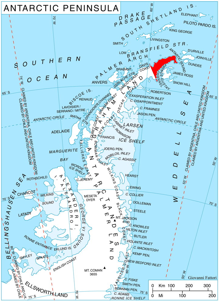
English: Location of Trinity Peninsula, Antarctica. |
| Date | |
| Bun | Own work, using map File:Ant-pen map.png by Giovanni Fattori. |
| Author | Edited by Apcbg |
Kieddagh:
I, the copyright holder of this work, hereby publish it under the following licenses:
This file is licensed under the Creative Commons Attribution-Share Alike 3.0 Unported license.
- You are free:
- to share – to copy, distribute and transmit the work
- to remix – to adapt the work
- Under the following conditions:
- attribution – You must give appropriate credit, provide a link to the license, and indicate if changes were made. You may do so in any reasonable manner, but not in any way that suggests the licensor endorses you or your use.
- share alike – If you remix, transform, or build upon the material, you must distribute your contributions under the same or compatible license as the original.

|
Permission is granted to copy, distribute and/or modify this document under the terms of the GNU Free Documentation License, Version 1.2 or any later version published by the Free Software Foundation; with no Invariant Sections, no Front-Cover Texts, and no Back-Cover Texts. A copy of the license is included in the section entitled GNU Free Documentation License. |
You may select the license of your choice.
Shennaghys y choadan
Crig er daayt/am ennagh son fakin er y choadan myr v’eh ec y traa shen.
| Daayt/Am | Ingin-ordaag | Towshanyn | Ymmydeyr | Cohaggloo | |
|---|---|---|---|---|---|
| bio | 12:09, 29 Mayrnt 2011 | | 720 × 989 (255 KB) | Apcbg | Updated per USGS definition. |
| 15:10, 25 Averil 2010 |  | 720 × 989 (255 KB) | Apcbg | {{Information |Description={{en|1=Location of Trinity Peninsula, Antarctica.}} |Source={{own}}, using map File:Ant-pen map.png by Giovanni Fattori. |Author=Edited by Apcbg |Date=2010-04-25 |Permission= |other_versions= }} [[Category:M |
Ymmyd y choadan
Ta ny 1 duillag eiyrtyssagh kianglt rish y choadan shoh:
Global file usage
The following other wikis use this file:
- Usage on ast.wikipedia.org
- Usage on az.wikipedia.org
- Boil burnu
- Qarvan burnu
- Retije buxtası
- Çernopeyev zirvəsi
- Kribul təpəsi
- Draqor təpəsi
- Bardarevo təpəsi
- Qornik təpəsi
- Prilep təpəsi
- Konuş təpəsi
- Vişeqrad təpəsi
- Obzor təpəsi
- Giqen zirvəsi
- İqnatiyev dağı
- Sirius təpəsi
- Tintyava zirvəsi
- Lardiqo zirvəsi
- Oqled zirvəsi
- Çoçoveni nunatakı
- Smin zirvəsi
- Kolobar nunatakı
- Survakari nunatakı
- Mureno zirvəsi
- Draka nunatakı
- Smokinya buxtası
- Çudomir buxtası
- Senokos nunatakı
- Lopyan təpəsi
- Siniger nunatakı
- Koburq zirvəsi
- Obidim zirvəsi
- Zanoqe təpəsi
- Eremiya təpəsi
- Qreben təpəsi
- Yarlovo nunatakı
- Kumata təpəsi
- Usage on bg.wikipedia.org
- Usage on ceb.wikipedia.org
- Usage on cs.wikipedia.org
View more global usage of this file.