
Coadan:Bản đồ Hà Nội.png
Size of this preview: 600 × 599 pixels. Other resolutions: 240 × 240 pixels | 481 × 480 pixels | 769 × 768 pixels | 1,025 × 1,024 pixels | 2,051 × 2,048 pixels | 3,000 × 2,996 pixels.
Jeeskeaylley ymlane (3,000 × 2,996 pixelyn, mooadys y choadan: 3.46 MB, sorçh MIME: image/png)
| Coontey |
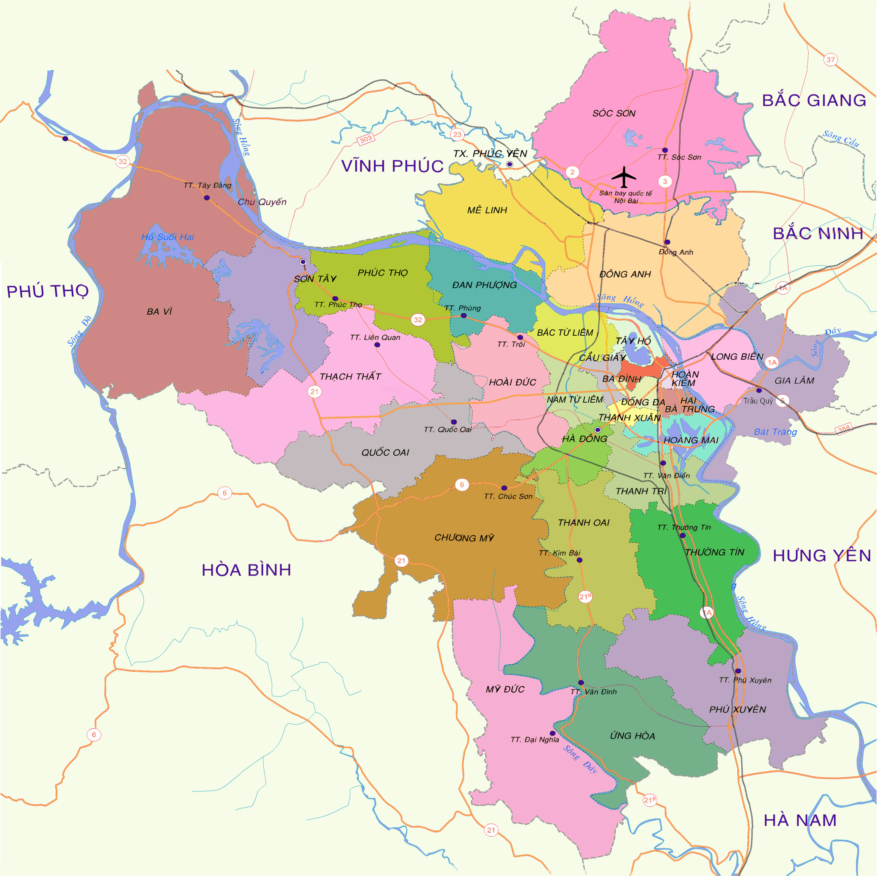
English: Map of Hanoi at the end of 2008
Tiếng Việt: Bản đồ Hà Nội cuối năm 2008 |
| Date | 15:19, ngày 30 tháng 12 năm 2008 (UTC) |
| Bun | vi:Tập tin:Bản đồ Hà Nội.png |
| Author | Lưu Ly |
| Permission (Reusing this file) |
This file is licensed under the Creative Commons Attribution 3.0 Unported license.
|
| Other versions | vi:Tập tin:Bản đồ Hà Nội (tạm).png |

.png)
| Annotations | This image is annotated: View the annotations at Commons |
| Camera location | | View this and other nearby images on: OpenStreetMap |
|---|
Shennaghys y choadan
Crig er daayt/am ennagh son fakin er y choadan myr v’eh ec y traa shen.
| Daayt/Am | Ingin-ordaag | Towshanyn | Ymmydeyr | Cohaggloo | |
|---|---|---|---|---|---|
| bio | 16:52, 27 Mee ny Nollick 2013 | | 3,000 × 2,996 (3.46 MB) | Tran The Vinh | chia đơn vị hành chính |
| 09:31, 27 Mayrnt 2009 |  | 2,976 × 2,972 (2.31 MB) | Newone | {{Information |Description={{en|1=Map of Hanoi at the end of 2008}} {{vi|1=Bản đồ Hà Nội cuối năm 2008}} |Source=vi:Tập tin:Bản đồ Hà Nội.png |Author=Lưu Ly |Date=15:19, ngày 30 tháng 12 năm 2008 |
Ymmyd y choadan
Ta ny 1 duillag eiyrtyssagh kianglt rish y choadan shoh:
Global file usage
The following other wikis use this file:
- Usage on arz.wikipedia.org
- Usage on bat-smg.wikipedia.org
- Usage on ba.wikipedia.org
- Usage on bcl.wikipedia.org
- Usage on be-tarask.wikipedia.org
- Usage on beta.wikiversity.org
- Usage on bxr.wikipedia.org
- Usage on ca.wikipedia.org
- Usage on ceb.wikipedia.org
- Usage on cs.wikipedia.org
- Usage on cv.wikipedia.org
- Usage on da.wikisource.org
- Usage on de.wikipedia.org
- Usage on de.wikisource.org
- Usage on de.wikiversity.org
- Usage on en.wikipedia.org
- Usage on en.wikisource.org
- Usage on en.wikivoyage.org
- Usage on eo.wikipedia.org
- Usage on es.wikipedia.org
- Usage on es.wikibooks.org
- Usage on es.wikinews.org
- Usage on es.wikisource.org
- Usage on fiu-vro.wikipedia.org
- Usage on fi.wiktionary.org
- Usage on frr.wikipedia.org
- Usage on fr.wikipedia.org
- Usage on fr.wikibooks.org
- Usage on fr.wikinews.org
- Usage on fr.wikiquote.org
- Usage on fr.wikisource.org
- Usage on fr.wikiversity.org
- Usage on fr.wiktionary.org
- Usage on fy.wikipedia.org
- Usage on ga.wikipedia.org
- Usage on gl.wikipedia.org
- Usage on gu.wikipedia.org
- Usage on haw.wikipedia.org
- Usage on hsb.wikipedia.org
View more global usage of this file.