
Coadan:Cronk ny Merriu.jpg
Cha nel jeeskeaylley ny smoo ry-gheddyn.
Cronk_ny_Merriu.jpg (640 × 429 pixelyn, mooadys y choadan: 99 KB, sorçh MIME: image/jpeg)
Giare-choontey
| Coontey |
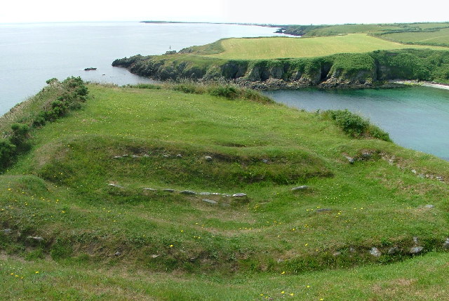
English: View from Cronk ny Merriu
Cronk ny Merriu is a coastal promontory fort with defensive ditch and rampart. The high ground location offers good views of the surrounding coast. Atlas of Hillforts number 3224 Behind the fort are the remains of a homestead. Originally believed to have been built in the Celtic Iron Age it was later re-occupied during the Norse Period. The site has a building nearly rectangular in construction with three doorways and a standard Norse central hearth. |
| Date | |
| Bun | From geograph.org.uk |
| Author | Nigel Homer |
| Permission (Reusing this file) |
Creative Commons Attribution Share-alike license 2.0 |
| Object location | | View this and other nearby images on: OpenStreetMap |
|---|
_region:IM_&language=gv)
Kieddagh:

|
This image was taken from the Geograph project collection. See this photograph's page on the Geograph website for the photographer's contact details. The copyright on this image is owned by Nigel Homer and is licensed for reuse under the Creative Commons Attribution-ShareAlike 2.0 license.
|
This file is licensed under the Creative Commons Attribution-Share Alike 2.0 Generic license.
Attribution: Nigel Homer
- You are free:
- to share – to copy, distribute and transmit the work
- to remix – to adapt the work
- Under the following conditions:
- attribution – You must give appropriate credit, provide a link to the license, and indicate if changes were made. You may do so in any reasonable manner, but not in any way that suggests the licensor endorses you or your use.
- share alike – If you remix, transform, or build upon the material, you must distribute your contributions under the same or compatible license as the original.
Shennaghys y choadan
Crig er daayt/am ennagh son fakin er y choadan myr v’eh ec y traa shen.
| Daayt/Am | Ingin-ordaag | Towshanyn | Ymmydeyr | Cohaggloo | |
|---|---|---|---|---|---|
| bio | 11:09, 29 Mean Fouyir 2007 | | 640 × 429 (99 KB) | Jmdesbois | {{geograph|103439|Nigel Homer}} |
Ymmyd y choadan
Ta ny 1 duillag eiyrtyssagh kianglt rish y choadan shoh:
Global file usage
The following other wikis use this file:
- Usage on cy.wikipedia.org
- Usage on de.wikipedia.org
- Usage on en.wikipedia.org
- Usage on fr.wikipedia.org
- Usage on sk.wikipedia.org
- Usage on www.wikidata.org