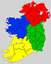
Coadan:Ireland location provinces.svg
Appearance

Size of this PNG preview of this SVG file: 400 × 500 pixels. Other resolutions: 192 × 240 pixels | 384 × 480 pixels | 614 × 768 pixels | 819 × 1,024 pixels | 1,638 × 2,048 pixels.
Jeeskeaylley ymlane (coadan SVG, 400 × 500 phixel dy ennymagh, mooadys y choadan: 335 KB)
Shennaghys y choadan
Crig er daayt/am ennagh son fakin er y choadan myr v’eh ec y traa shen.
| Daayt/Am | Ingin-ordaag | Towshanyn | Ymmydeyr | Cohaggloo | |
|---|---|---|---|---|---|
| bio | 13:52, 25 Mean Fouyir 2020 |  | 400 × 500 (335 KB) | Draceane | -background |
| 13:43, 25 Mean Fouyir 2020 |  | 400 × 500 (362 KB) | Draceane | cleanup, colorblind version | |
| 16:23, 1 Mee ny Nollick 2018 |  | 1,776 × 2,209 (2.4 MB) | Draceane | -JPEG artifacts mapped to SVG | |
| 03:59, 8 Boaldyn 2012 |  | 1,776 × 2,209 (2.4 MB) | Ninrouter | == {{int:filedesc}} == {{Information |Description={{en|1=A map highlighting the four provinces of Ireland.}} |Source={{Derived from|Ireland_location_provinces.jpg|display=50}} |Date=2012-05-08 03:53 (UTC) |Author=*[[:File:Ireland_location_provinces.jpg... |
Ymmyd y choadan
Ta ny 1 duillag eiyrtyssagh kianglt rish y choadan shoh:
Global file usage
The following other wikis use this file:
- Usage on be.wikipedia.org
- Usage on br.wikipedia.org
- Usage on cs.wikipedia.org
- Usage on el.wikipedia.org
- Usage on en.wikipedia.org
- Usage on es.wikipedia.org
- Usage on fr.wikipedia.org
- Usage on ga.wikipedia.org
- Usage on gd.wikipedia.org
- Usage on incubator.wikimedia.org
- Usage on io.wikipedia.org
- Usage on ja.wikipedia.org
- Usage on ka.wikipedia.org
- Usage on no.wikipedia.org
- Usage on pt.wikipedia.org
- Usage on ru.wikipedia.org
- Usage on sco.wikipedia.org
- Usage on sk.wikipedia.org
- Usage on sr.wikipedia.org
- Usage on tr.wikipedia.org
- Usage on uk.wikipedia.org
- Usage on ur.wikipedia.org
- Usage on vi.wikipedia.org
- Usage on zh-yue.wikipedia.org
- Usage on zh.wikipedia.org


