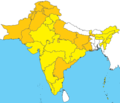
Coadan:Urdu official-language areas.png
Appearance

Size of this preview: 582 × 600 pixels. Other resolutions: 233 × 240 pixels | 466 × 480 pixels | 988 × 1,018 pixels.
Jeeskeaylley ymlane (988 × 1,018 pixelyn, mooadys y choadan: 465 KB, sorçh MIME: image/png)
Shennaghys y choadan
Crig er daayt/am ennagh son fakin er y choadan myr v’eh ec y traa shen.
| Daayt/Am | Ingin-ordaag | Towshanyn | Ymmydeyr | Cohaggloo | |
|---|---|---|---|---|---|
| bio | 13:30, 27 Jerrey Souree 2023 |  | 988 × 1,018 (465 KB) | PadFoot2008 | Centred and updated map. |
| 06:42, 27 Jerrey Souree 2023 |  | 800 × 719 (124 KB) | Kwamikagami | rv. ridiculous file size, which actually had worse resolution; add Andhra Pradesh | |
| 07:36, 4 Toshiaght Arree 2022 |  | 1,436 × 1,221 (1.4 MB) | Бмхүн | Better resolution | |
| 07:13, 4 Toshiaght Arree 2022 |  | 1,436 × 1,221 (863 KB) | Бмхүн | Chhattisgarh state | |
| 10:11, 30 Jerrey Geuree 2022 |  | 1,436 × 1,221 (1.01 MB) | Бмхүн | new borders after India and Pakistan change states and provinces | |
| 23:52, 19 Jerrey Fouyir 2016 |  | 800 × 719 (150 KB) | Kwamikagami | Jharkhand per http://nclm.nic.in/shared/linkimages/NCLM50thReport.pdf | |
| 00:26, 14 Jerrey Geuree 2016 |  | 800 × 719 (150 KB) | Gaurh | *removing en:Uttarakhand per request. Urdu is not official language in en:Uttarakhand! | |
| 03:42, 7 Mean Souree 2015 |  | 1,184 × 1,064 (146 KB) | Kwamikagami | Telangana | |
| 16:55, 5 Mean Souree 2015 |  | 1,071 × 917 (142 KB) | Kwamikagami | Reverted W. Bengal -- there's no source for this | |
| 08:24, 21 Averil 2014 |  | 1,071 × 917 (111 KB) | Irfan Arshad | Reverted to version as of 14:45, 26 March 2014 user has no refernce, urdu is official in west bengal see West Bengal |
Ymmyd y choadan
Ta ny 1 duillag eiyrtyssagh kianglt rish y choadan shoh:
Global file usage
The following other wikis use this file:
- Usage on af.wikipedia.org
- Usage on am.wikipedia.org
- Usage on an.wikipedia.org
- Usage on ast.wikipedia.org
- Usage on be-tarask.wikipedia.org
- Usage on be.wikipedia.org
- Usage on bg.wikipedia.org
- Usage on ca.wikipedia.org
- Usage on ceb.wikipedia.org
- Usage on crh.wikipedia.org
- Usage on de.wikipedia.org
- Usage on el.wikipedia.org
- Usage on en.wikipedia.org
- Usage on es.wikipedia.org
- Usage on eu.wikipedia.org
- Usage on fa.wikibooks.org
- Usage on gl.wikipedia.org
- Usage on gn.wikipedia.org
- Usage on hak.wikipedia.org
- Usage on haw.wikipedia.org
- Usage on hu.wikipedia.org
- Usage on id.wikipedia.org
- Usage on incubator.wikimedia.org
- Usage on inh.wikipedia.org
- Usage on it.wikipedia.org
- Usage on it.wikiquote.org
- Usage on kbp.wikipedia.org
- Usage on km.wikipedia.org
- Usage on kn.wikipedia.org
- Usage on ks.wikipedia.org
- Usage on lv.wikipedia.org
- Usage on min.wikipedia.org
- Usage on mn.wikipedia.org
- Usage on ne.wikipedia.org
- Usage on new.wikipedia.org
- Usage on or.wikipedia.org
- Usage on pi.wikipedia.org
- Usage on pnb.wikipedia.org
- Usage on pt.wikibooks.org
- Usage on sat.wikipedia.org
- Usage on sa.wikipedia.org
- Usage on sco.wikipedia.org
- Usage on simple.wikipedia.org
- Usage on si.wikipedia.org
- Usage on skr.wikipedia.org
- Usage on sl.wikipedia.org
- Usage on sr.wikipedia.org
- Usage on tcy.wikipedia.org
View more global usage of this file.

