
Coadan:Map of the Ancient Rome at Caesar time (with conquests)-en.svg

Size of this PNG preview of this SVG file: 800 × 486 pixels. Other resolutions: 320 × 195 pixels | 640 × 389 pixels | 1,024 × 623 pixels | 1,280 × 778 pixels | 2,560 × 1,557 pixels | 1,674 × 1,018 pixels.
Jeeskeaylley ymlane (coadan SVG, 1,674 × 1,018 pixelyn dy ennymagh, mooadys y choadan: 2.8 MB)
Giare-choontey
| Coontey |
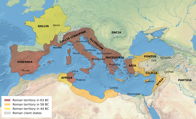
English: Map of the Roman Republic's empire and vassal states, 1st century BC. All labels in Latin. Legend in English. |
| Date | |
| Bun | Own work based on: Map of the Ancient Rome at Caesar time (with conquests)-fr.svg |
| Author | User:Historicair, Ifly6 |
| Other versions |
[]
|
-en.svg)
-es.svg)
-fr.svg)
-zh.svg)
-en.svg)
Kieddagh:
I, the copyright holder of this work, hereby publish it under the following license:
This file is licensed under the Creative Commons Attribution-Share Alike 3.0 Unported license.
- You are free:
- to share – to copy, distribute and transmit the work
- to remix – to adapt the work
- Under the following conditions:
- attribution – You must give appropriate credit, provide a link to the license, and indicate if changes were made. You may do so in any reasonable manner, but not in any way that suggests the licensor endorses you or your use.
- share alike – If you remix, transform, or build upon the material, you must distribute your contributions under the same or compatible license as the original.
Shennaghys y choadan
Crig er daayt/am ennagh son fakin er y choadan myr v’eh ec y traa shen.
| Daayt/Am | Ingin-ordaag | Towshanyn | Ymmydeyr | Cohaggloo | |
|---|---|---|---|---|---|
| bio | 05:30, 16 Mayrnt 2023 | | 1,674 × 1,018 (2.8 MB) | Ifly6 | add labels for dacia and parthia |
| 05:26, 16 Mayrnt 2023 |  | 1,674 × 1,018 (2.74 MB) | Ifly6 | reproject in gis with natural earth 2. remove unnecessary details. | |
| 23:56, 30 Averil 2022 |  | 2,043 × 1,211 (361 KB) | Ifly6 | really made it all text ; also added veneti label | |
| 23:48, 30 Averil 2022 |  | 2,043 × 1,211 (387 KB) | Ifly6 | update font to sens-serif all and re-type all labels to be in text | |
| 00:04, 30 Averil 2022 |  | 2,043 × 1,211 (557 KB) | Ifly6 | hopefully the city dots will appear ''this time'' | |
| 19:58, 28 Averil 2022 |  | 2,043 × 1,211 (552 KB) | Ifly6 | normalise some text names and sizes. i guess we'll see if the city markers show up this time. | |
| 19:50, 28 Averil 2022 |  | 2,043 × 1,211 (571 KB) | Ifly6 | Uploaded own work with UploadWizard |
Ymmyd y choadan
Ta ny 1 duillag eiyrtyssagh kianglt rish y choadan shoh:
Global file usage
The following other wikis use this file:
- Usage on cs.wikipedia.org
- Usage on en.wikipedia.org
- Usage on et.wikipedia.org
- Usage on hr.wikipedia.org
- Usage on ja.wikipedia.org
- Usage on ka.wikipedia.org
- Usage on lt.wikipedia.org
- Usage on ru.wikipedia.org
-en.svg)