Tyne as Wear
Appearance
| Tyne as Wear Tyne and Wear |
|||
|---|---|---|---|
| — Coontae jesh-chliaghtagh — | |||
|
|||
 |
|||
 |
|||
| Co-ordnaidyn: 54°58′26″N 01°36′48″W / 54.97389°N 1.61333°W | |||
| Çheer | |||
| Çheer cho-ayrnagh | |||
| Ard | Sostyn Hiar Hwoaie | ||
| Reiltys | |||
| - MPyn | 12 |
||
| Eaghtyr | |||
| - Yn clane | 538 km² (207.7 mi ker) | ||
| Earroo yn phobble (2008)[1] | 1,093,400 | ||
| - Glooaght y phobble | 2,025/km² (5,244.7/mi ker) | ||
| Cryss hraa | GMT (UTC+0) | ||
| - Sourey (TTSL) | BST (UTC+1) | ||
| Coad ONS | 2D | ||
| NUTS 2 | UKC22/23 | ||
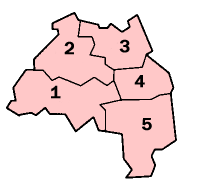
She coontae jesh-chliaghtagh Hostyn as coontae moirvaljagh eh Tyne as Wear. T'eh soit ec shiar twoaie ny çheerey. Va'n coontae moirvaljagh bunnit 'sy vlein 1974. Ta queig baljyn corpagh echey: Tyneside Yiass, Tyneside Hwoaie, Ard-valley Balley Chashtal Noa, Gateshead as Ard-valley Sunderland.
T'eh çhemmit liorish Northumberland da'n twoaie as Coontae Durham da'n jiass.
Imraaghyn
[reagh | edit source]- ↑ Population estimates for UK, England and Wales, Scotland and Northern Ireland, Mid-2008. National Statistics Online. Office for National Statistics.
Kianglaghyn magh
[reagh | edit source]Ta tooilley mean ayns Wikimedia Commons bentyn rish: Tyne and Wear.

