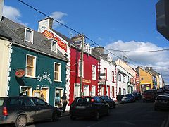
Yn Dein
Appearance
| Y Dein An Daingean | ||
 Straid Yuan, y Dein | ||
|---|---|---|
| Soiaghey | ||
|
| ||
| Ingagh ogheragh Nerin Q444012 | ||
| Staydraa | ||
| Queiggey: | Queiggey Mooan | |
| Coontae: | Coontae Cherree | |
| Dáil Éireann: | Kerree Yiass | |
| Parlamaid ny h-Oarpey: | Jiass | |
| Coad jeeley: | +353 66 | |
| Eaghtyr: | 2.06 km²[1] | |
| Yrjid: | 2 m | |
| Earroo yn phobble (2006) | 1,920[2] | |
Ta'n Dein (Yernish: An Daingean ny Daingean Uí Chúis, Baarle: Dingle) ny valley ta soit ayns Gaeltaght Cherree, Pobblaght Nerin, 50 km sheear sheear yiass veih Traie Lee as 80 km sheear sheear hwoaie veih Keeill Airney. Ta'n balley soit er purt najooragh er lieh-innys y Dein. T'ad y turrysaght, yn eeasteyraght as yn eirinys preeu-çhynskylyn y valley.
Baljyn lannoonit
[reagh | edit source]| Çheer | Boayl | Coontae / Slyst / Ard / Steat | Lannoonit rish | Date | |||
|---|---|---|---|---|---|---|---|
| SUA | Santa Barbara | California | Y Dein | 2003 | |||
| Yn Iddaal | Tolfa | Lazio | Y Dein | 1974 |
Imraaghyn
[reagh | edit source]- ↑ "Table 6 - Population and area of each Province, County, City, urban area, rural area and Electoral Division, 2002 and 2006" (PDF). Census 2006, Volume 1 - Population Classified by Area. Oik Staydraa Nerin. 2007-04-26. dgn. d. 90. Feddynit magh er 2010-07-25. (Baarle)
- ↑ "Table 7 - Persons in each town of 1,500 population and over, distinguishing those within legally defined boundaries and in suburbs or environs, 2002 and 2006" (PDF). Census 2006, Volume 1 - Population Classified by Area. Oik Staydraa Nerin. 2007-04-26. dgn. d. 122. Feddynit magh er 2010-07-25. (Baarle)

